


leat

whisper73
User
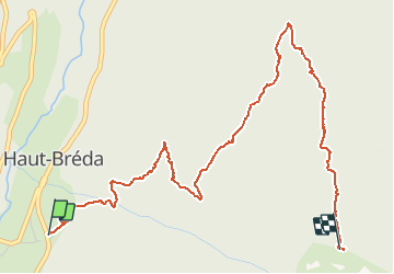

Length
5.5 km

Max alt
1819 m

Uphill gradient
891 m
Km-Effort
14.4 km

Min alt
935 m

Downhill gradient
12 m
Boucle
No
Creation date :
2016-03-09 00:00:00.0
Updated on :
2016-03-09 00:00:00.0
1h57
Difficulty : Easy

FREE GPS app for hiking
 SityTrail
IGN / Geographical institutes
SityTrail Plus
The world is yours!
About
Trail Walking of 5.5 km to be discovered at Auvergne-Rhône-Alpes, Isère, Le Haut-Bréda. This trail is proposed by whisper73.
Positioning
Country:
France
Region :
Auvergne-Rhône-Alpes
Department/Province :
Isère
Municipality :
Le Haut-Bréda
Location:
La Ferrière
Start:(Dec)
Start:(UTM)
271719 ; 5022523 (32T) N.
Comments